


Apex Hunt
Every stand of public forest, scored for grouse and woodcock. On a map that works with no signal.
Apex Hunt reads the state and federal forest inventory for every stand of public land in Michigan, Wisconsin and Minnesota, puts a number on each covert, and tells you which one to walk first and which way to walk it. More states are on the way.


Free to download. Apex Pro is $4.99 a month after the trial. The map, your journal and the plant guide stay free, always.
232,525
inventoried stands across MI, WI and MN
23,154
coverts: neighboring stands worth a morning together
3 states
Michigan, Wisconsin and Minnesota, with more being added
Offline
works with no signal: it's all on your phone
We built the vest for the dog. We built Apex for the hunter.
Field Armor started with a problem in the field: generic vests that didn't hold up for a hard-running bird dog. Apex Hunt started with a question we kept asking every fall: of all this public land, which covert is worth the morning?
The answer was already written down, stand by stand, in the forester's records. Apex reads those records, scores every covert, and puts the answer on your phone, ready to use where there's no signal.
It doesn't show you pins. It shows you cover.
Other apps put a dot where somebody once shot a bird. Apex scores the woods themselves, from the same records the foresters keep, so a good covert is a good covert whether or not anyone has posted about it.
PICKS
Tonight's best covert, and why.
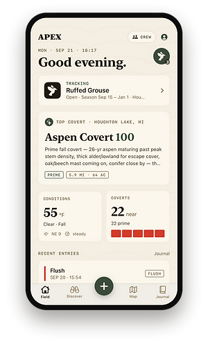
Open the app and the Field screen gives you the brief: your top covert for the conditions right now, the reason in a hunter's words (26-year aspen past peak stem density, thick alder for escape cover, conifer close by), how far it is, how many acres, and how many prime coverts are near you. On the map, every covert carries its score.

HUNT IT
Numbered stands. Where to park. Which way to walk.
Open a covert and Apex draws every stand inside it over the satellite, numbered in the order to hunt. The red dot is where to park and the dashed line is the walk. The plan turns with the wind: enter from the west, work into the east wind. The bright green is the thick cover the LiDAR measured at bird height, inside the stand, where the birds actually are.
TIMBER
The forester's record for every stand.
Tap any stand for its cover type, age and acreage, the canopy by species and percent, the understory, and the DNR's own notes, word for word. Browse and filter every stand in the state. Standing in one that's been cut, flooded or grown shut? Say so in three taps and your map learns.


SCOUT
Plan November in August.
Scout mode re-ranks every covert for the month, the weather and the time of day you choose, so you know which coverts will be worth it before the leaves are down. Drag the wind and the entry plan turns with it. On the day, the conditions sheet reads the real forecast: the best window, legal light, and what the birds are likely doing.
YOUR SEASON
Every flush sharpens your map.
Log a flush, a brood, drumming or a blank, and Apex tunes its scores to your ground. The Season page reads it back to you: birds, flushes, days out, miles walked, and the cover that paid off. All of it stays on your phone unless you choose to share it.

NO SIGNAL NEEDED
The coverts, stands and scores live on your phone and are ranked on your phone. Download your map over Wi-Fi before you go.
CREW
Your hunting party on one map: shared coverts, live location when you turn it on, and chat for when there's a bar of signal.
TRAILS AND TURN-BY-TURN
Forest roads, two-tracks and snowmobile trails, with directions to any pin you drop.
One plan. Two ways in.
The app is free to download. Pro is $4.99 a month and adds PICKS, TIMBER and Crew. The map, your journal and the plant guide stay free, always.
30 days free
Through Field Armor, then $4.99 a month.
Billed by Field Armor, right here on fieldarmorusa.com.
Cancel any time in your Field Armor account.
Sign in to the app with the same email, and Pro comes with it.
14 days free
On iPhone, then $4.99 a month.
Subscribe inside the app, billed by Apple.
Cancel any time in your iPhone's Settings.
Sign in with Apple or with your email.
One subscription is all you need, so don't buy both. A card is required to start the Field Armor trial, and you won't be charged until day 31.
Questions
Who makes Apex Hunt?
Field Armor, the same company behind the Field Armor vests. Apex Hunt was built and field-tested in Michigan.
What's free, and what does Pro add?
Free, always: the map with roads, trails and public land, your pins and recorded tracks, the journal and the plant field guide. Pro adds PICKS (scored coverts on the map and ranked, with a guide for each), TIMBER (every stand in the state to browse and filter) and Crew.
Does it work with no signal?
Yes. The coverts, stands and scores are stored on your phone and ranked on your phone. Download the map for your area over Wi-Fi before you go and the imagery comes with you.
How do I cancel?
If you subscribed on iPhone: Settings, then your name, then Subscriptions. If you subscribed through Field Armor: log in here on fieldarmorusa.com and cancel under My Subscriptions. Either way, Pro stays on until the end of the period you've paid for.

Which of these ten thousand acres is worth a morning?
Apex is the answer we wanted on our own phones: the forester's records, the laser's measurements and our own logs, in one place, working where the signal isn't.